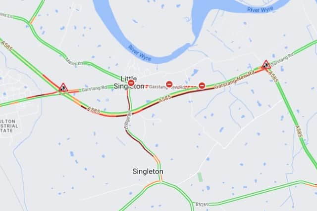
Lancashire traffic and travel updates for your journey home after snow falls across Lancashire
and live on Freeview channel 276
Lancashire has become a winter wonderland overnight with snow continuing to fall across the whole county this morning.
A Met Office yellow weather warning for snow and ice is now in place as the forecaster warns of disruption to travel on roads and railways today, while an amber cold weather alert has also been issued by the UK Health Security Agency.
Follow our live blog for the latest traffic, travel and weather updates from across the region.
LIVE Lancashire snow, traffic and weather updates as Met Office warnings in place
Lancashire Fire and Rescue issues advice for residents planning to heat their homes without central heating
It's bitterly cold this week and LFRS want to remind you to be safe and save if you're trying to cut costs and plan to heat your home without central heating this winter.
You can protect your family and your home, by following these steps:
- If you have a chimney, get it swept before use.
- Only buy portable heaters from reputable suppliers and keep them clear of anything that could catch fire.
- Make sure electric blankets are in good condition and get them serviced before use.
- Never use electric blankets and hot water bottles at the same time.
- Avoid overheating wheat bags – they can catch fire in the microwave.
Can you be sued for clearing snow from your path or pavement?
The Government has issued advice to anyone who may be put off picking up a spade and clearing away snow and ice from public paths outside their homes, for fear of legal action if someone were to be injured.
Weather warnings for ice and snow are inevitable during winter months and making journeys on foot along footpaths and pavements can be treacherous.
However, conscientious people shouldn't be put off clearing ice and snow themselves according to Government advice. The Department for Transport says that "it’s unlikely that you’ll be sued or held responsible if someone is injured on a path or pavement if you’ve cleared it carefully."
The Met Office also echoed the advice and clarified that "people walking on snow and ice have a responsibility to be careful themselves."
That being said, if you are planning to clear snow and ice yourself, you'll need to be sure it is cleared correctly.
Click HERE to find some top tips from the Department of Transport and the Met Office to help you do it safely.


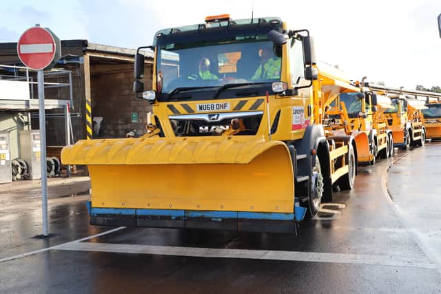
Ice warning as gritting efforts continue
People are being warned to be careful due to very icy conditions forecast first thing on Wednesday morning as the freezing weather continues.
Lancashire County Council's gritting teams will be gritting again this evening before temperatures fall well below zero, and patrolling throughout the night in case further gritting is needed to cope with wintry showers forecast.
The Met Office has issued yellow weather warnings for snow and ice covering Lancashire until a thaw expected to arrive on Friday.
The council's gritting teams have again been treating the approximately 1,500 miles of the county council's priority road network today following the snow which arrived overnight on Monday.
County Councillor Rupert Swarbrick, cabinet member for highways and transport, said: "Our gritting teams have been very busy over the past 24 hours, with yesterday's action ensuring that the main routes cleared quickly this morning once the early morning traffic mixed the salt already on the roads with the snow which followed.
"They've been busy again today as the snow showers continued in many areas throughout this morning, with a particular focus on the higher routes which were most affected by the snowfall.
"We're expecting things to be very icy over the next couple of days as the skies clear, and temperatures fall well below zero at night, and stay near freezing throughout the day.
"There could also be showers at times, which could create difficult conditions on any road or pavement as it turns to ice on contact with the freezing surface, particularly if any salt we've put down has been washed away in the process.
"This is why our teams will be patrolling continually over the coming hours to try to keep the main routes as safe as possible, however please be aware that any surface could be icy, even on the main routes which we'll be gritting. Untreated surfaces could be particularly treacherous, and I'd ask people to be very careful on their journeys, particularly first thing in the morning."
Severe weather alert for snow affecting the North West region
There is a severe weather alert for snow affecting the North West region between 5am until 11.59pm on Tuesday, January 16.
Road users are advised to check ahead and plan for disruption to their journeys.
A small area of low pressure is going to bring widespread snow into the Northwest on Tuesday.
While the behaviour (track and intensity) of this small scale feature is not yet fully resolved, it has the potential to bring travel disruption and will develop in two stages, complicating the forecast.
Snow showers are going to feed into the Northwest region during the early hours of Tuesday, particularly along coastal areas where they will be more frequent.
Whilst accumulations will vary due to their erratic nature, 1-3cm of snow is expected widely in western parts (from Carlisle down to Manchester), perhaps 3-5cm in places, whereas eastern parts will remain mostly dry initially.
A south-westerly wind (30-40mph gusts) will then pick up later in the morning, allowing the showers to merge into a more organised band of precipitation.
The snow will turn to rain at low levels and on coastal locations during the afternoon, initiating a thaw, whilst migrating towards high ground with 1-3cm widely above 200m by 16/2100 and up to 5-10cm on top of the A66 and the M62.
The band of rain, sleet and snow will peter out during the evening whilst slowly sinking southwards.
Comment Guidelines
National World encourages reader discussion on our stories. User feedback, insights and back-and-forth exchanges add a rich layer of context to reporting. Please review our Community Guidelines before commenting.